In my job at the European Space Agency we look at what satellite applications can do for non-space sectors of society. Sometimes, however, you simply have to stop what you do and enjoy the majestic beauty of some of the images we get!
I have long believed that our space instruments - Earth Observation Satellites or the Hubble Space Telescope - deserve an award for the artistic beauty of their images. Here are 5 of my favourites from recent months together with a short description of what you are seeing.
I hope you will enjoy!
The Musa Bay at the northern end of the Persian Gulf of Iran

In the centre you can see the port city of Bandar Imam Khomeini. The city is situated at the terminus of the Trans-Iranian Railway, a route that links the Persian Gulf with Iran’s capital Tehran. The dark area to the right of the port is Musa Bay, a shallow estuary. The large geometric structures along the top appear to be evaporation ponds for extracting naturally occurring minerals from the ground. The left side of the image is dominated by the marshes and mudflats of the Shadegan wildlife refuge. It is the largest wetland in Iran and plays a significant role in the natural ecology of the area, including the wintering habitat for a wide variety of migratory birds. It is the most important site in the world for a rare species of aquatic bird: the marbled duck. The northern part of the wetland is a vital freshwater habitat for many endangered species and is considered a wetland of international importance. Therefore, satellite images of this landscape are frequently viewed by organisations working with environmental protection.
Australia’s Lake MacKay
.jpg)
The lake is located on the border of the states of western Australia and its northern territory at the edge of the Great Sandy Desert, which covers nearly 285 000 sq km. The salt lake sees water only after seasonal rainfall, if at all. It is classified as an ephemeral lake, meaning it exists only after precipitation compared to a seasonal lake, which sees water for longer periods. About half of Australia’s rivers drain inland and often end in ephemeral salt lakes like these. The greens and blues in this image show desert vegetation or algae, soil moisture and minerals (most of which is salt). On some of the brown ‘islands’, and on the shore in the lower right, we can see the east–west sand ridges forming lines in the landscape.
The Rann of Kutch seasonal salt marsh in western India
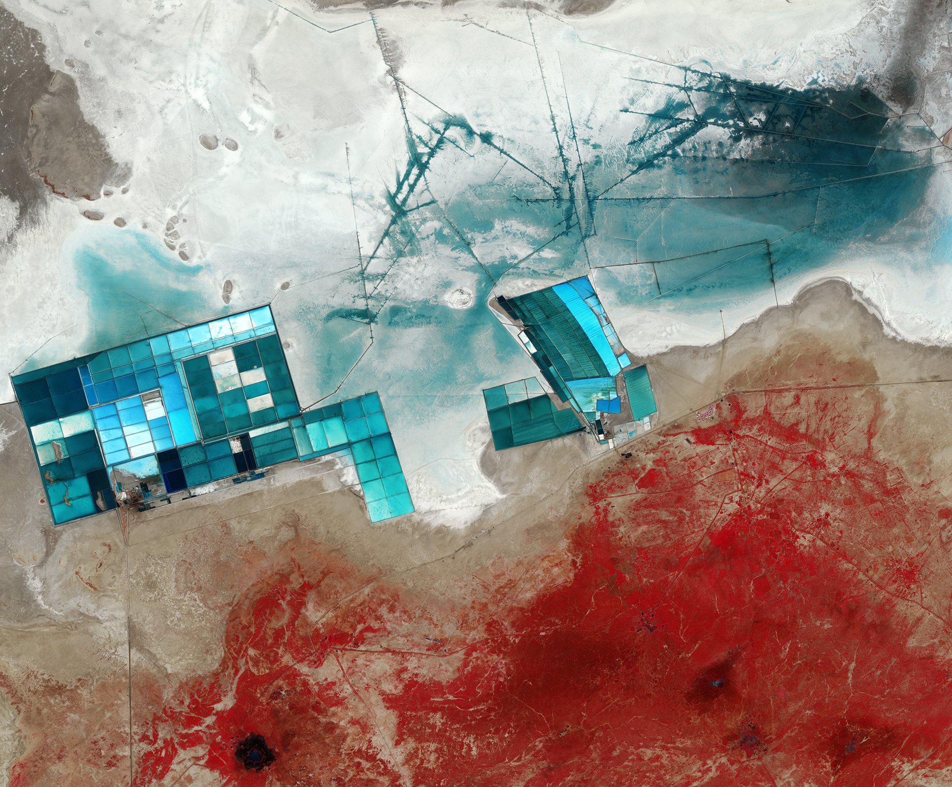
The Rann of Kutch seasonal salt marsh in western India is one of the largest salt deserts in the world. During the summer monsoon season, the area fills with water which then disappears in the drier winter season. The vast white desert is a popular tourist destination, in particular for the Rann Utsav festival. The festival centres around a luxury “tent city”, barely visible central right as a series of semi-circles.
Large salt evaporation ponds dominate this image as blue squares. These ponds are part of one of the major projects here, which is the production of potassium sulphate, commonly used in fertiliser. To give an indication of the size of these ponds, the width of the cluster on the left is nearly 13km! The lines (upper centre) are ditches used to control the flow of the water for the ponds. In this false-colour image, the strength of the blue colour in the pools and surrounding land depend on the mineral content, as well as the depths of the pools. Meanwhile, the red colours seen at the bottom of the image is vegetation (plants absorbs more of the red part of the electromagnetic spectrum to drive photosynthesis, making them appear red in images that include this part of the spectrum). This area is the Banni grasslands, known for its rich biodiversity. Today, Banni’s vegetation is sparse and highly dependent on rainfall, but reoccurring droughts are increasing pressure on the arid region. Other factors, including overgrazing and the invasion of a non-native thorny shrub, are also a stress factor on the environment. Satellite images are often used to monitor this development over time.
The Ötztal Alps of Tyrol in western Austria
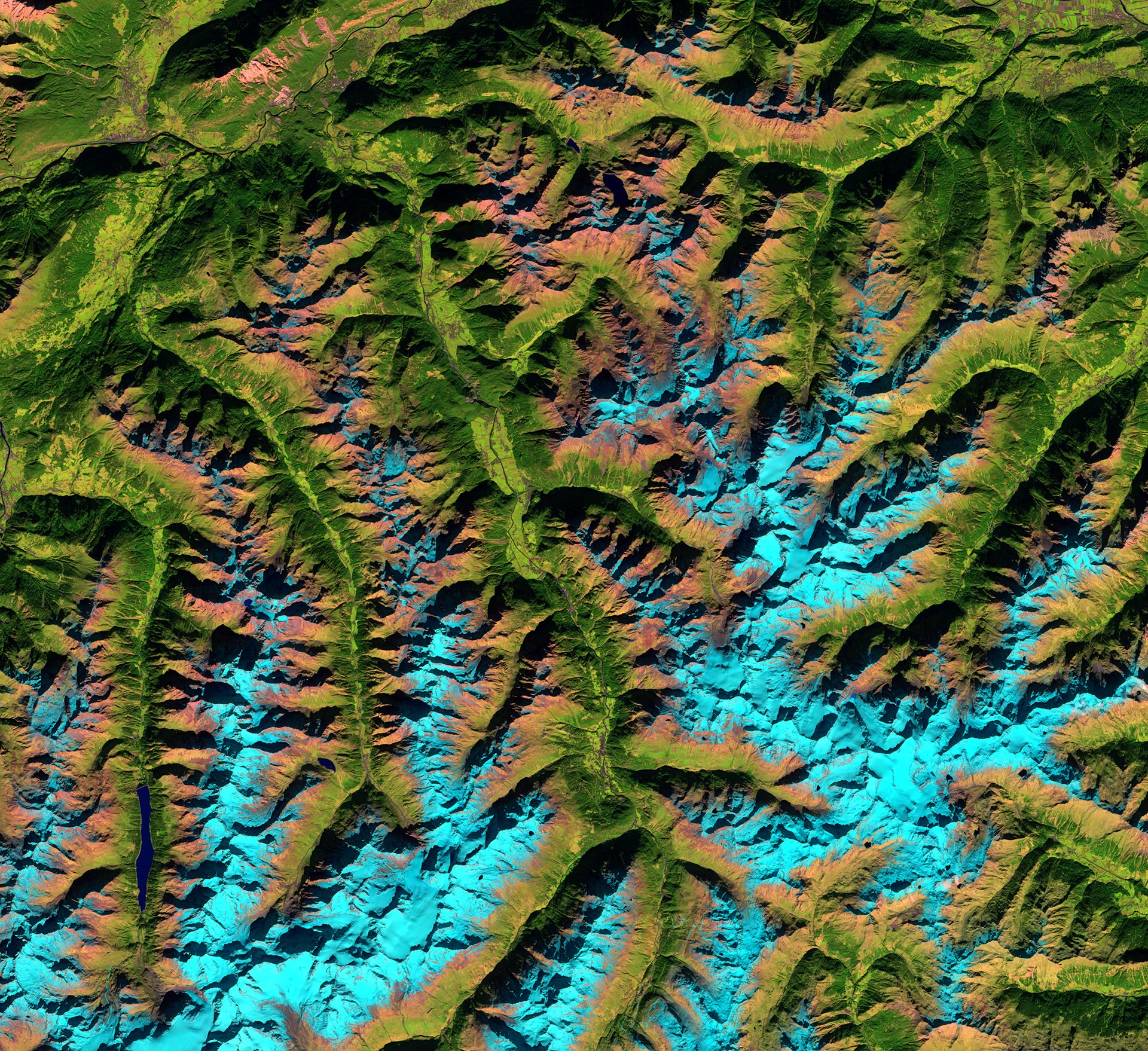
The shadows across the image may play tricks on the eye, resulting in the valleys (the green areas) look higher than the light Blue Mountains. You may want to try rotating the image, or turning your head to the side so the shadows fall in a different direction, to ‘fix’ this optical illusion. The reason why the snow appears in shades of blue because of the “false-colour” filter that has been used using light in the near- and shortwave infrared part of the spectrum. This colouring makes it easier to distinguish between snow and vegetation and to differentiate between clouds and snow (which can be difficult in other parts of the spectrum as they are usually both white).
In the upper left we can see part of the Inn River, flowing east from the Swiss Alps and through Austria and Germany before entering the Danube (not pictured). The land in the Inn river valley and other river valleys appear green with patches of agriculture. The highest peak in the Ötztal range is Wildspitze, standing over 3770 m. The mountain is visible in the lower-left corner, east of the elongated lake, Gepatschspeicher. Satellite images help measure the amount of snow gathered in the mountains, which is highly valuable information for the local hydropower companies and other's interested in projected electricity prices.
The Gobi Desert in Southern Mongolia and northern China
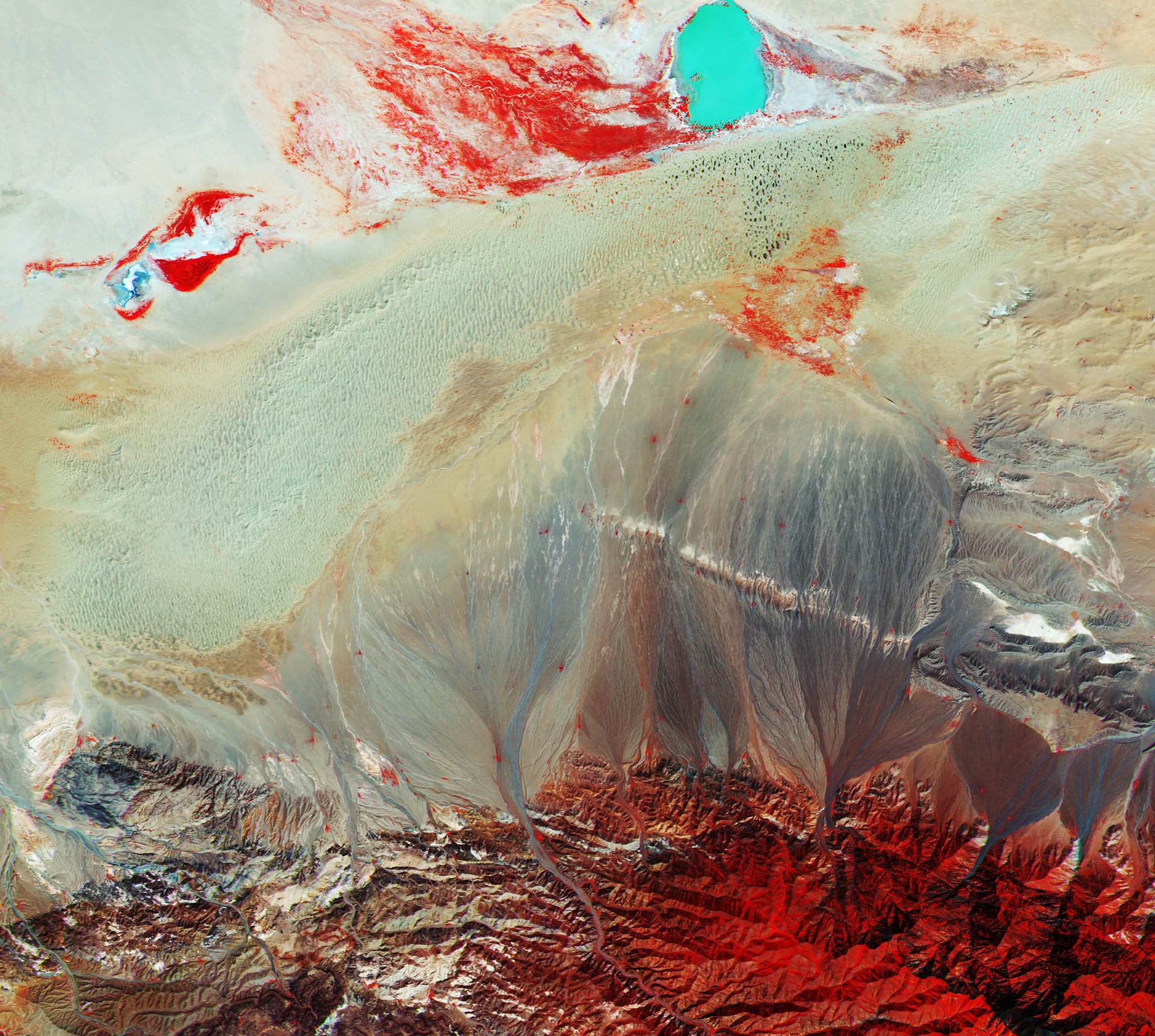
Home to the Gobi desert, Mongolia is predominantly a sandy and rocky plain with an average elevation of 1500 m above sea level. At the bottom you can see part of the Baga Bogd Mountain range with its highest peak reaching 3600m.
There is a very distinct body of water towards the top right part of the image, the Taatsiin Tsagaan Lake, one of the four saline lakes that make up the Valley of the Lakes. The lake’s depth and high concentration of salt give the water a vivid turquoise colour. The lines seen from the mountains reaching down into the desert are made by erosions where the eroded soil, with the help of rain, is carried from the mountain slopes to lower lands. In the warmer month, some low vegetation can be found also in the desert and rocky mountains. These, along with some scattered trees, provide the red colours seen in the southern mountains and close to the waters. Varying tones of red represent the different types of vegetation and densities and condition of the plants.
Want to try it out yourself?
All images above were taken by the European Sentinel 2 A or B satellites. You can download the raw data from these yourself for free here, which can be processed professionally by the free tool snap. Or you may want to find and process images online here!
I hope to share more of these breathtaking images and make it a regular theme for my steemit blog. If there are parts of the world (perhaps where you live) you want to see an image of please let me know and I’ll dig it up!
Thank you for reading this far! My next posts will cover:
- “My interviews with 25 Astronauts, and what it taught me about life, our planet, and much more”
- “The UK to build the world’s first commercial Astronaut training centre – and what it means for the future of space exploration”
- “So I built and launched a Pink rocket at NASA Kennedy Space Center”
- “5 incredible things we can now do with satellites! #1”
So Follow me and stay tuned for more!