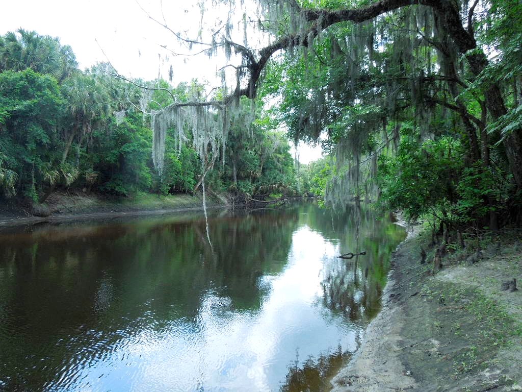
Photo : the view downstream on the Peace River, as seen from the boat ramp.
Hunting the dark waters and sandy banks of Florida's Peace River - in search of ancient bones, teeth, and artifacts.
SOME BACKGROUND :
For a span of three years, I had access to a large stretch of private property along on undeveloped section of the Peace River. This area had no residential or commercial development anywhere near it, and the only man-made things in the vicinity were phosphate mines and large citrus farms. The phosphate mines are here because of the presence of the Bone Valley Formation. Bone Valley is a phosphate-rich region of Florida that is also known for it’s world-class deposits of fossils.
Bone Valley contains rich layers of Miocene marine fossils, along with Pliocene and Pleistocene megafauna. Unfortunately, Florida was under water at the time of the dinosaurs, so there are no dinosaurs fossils found here. But, there are plentiful deposits filled with the remains of mammoth, mastodon, giant ground sloth, sabre tooth cat, dire wolf, glyptodont, horse, camel, bison, tapir, and dozens of other Pliocene/Pleistocene species. Intermixed with these are Miocene marine fossils such as megalodon shark, numerous other shark species, whale and dugong. The Peace River area was a megalodon nursery during the Miocene, so the number and quality of teeth recovered here are superior to most deposits elsewhere. It is also not uncommon to find fossilized dugong ribs with megalodon predation marks on them. So, there is wide diversity of fossils for collectors and scientists of any particular interest.
The Peace River runs for well over 100 miles, starting near Bartow Florida and eventually winding it’s way to the bay on the Gulf Mexico at Punta Gorda. It is partially spring-fed, but most of it’s flows comes from the surrounding Peace River flood basin of low-lying wetlands. The area around Zolfo Springs and Arcadia are highly regarded by fossil hunters because of their easy access via public parks. There are lesser-known fossil deposits along isolated stretches of the river and the many side creeks that feed into it. My hunting partner (my son Josh) and I frequently canoe or kayak new stretches of the river to scout for promising areas to dig for fossils. Since we both have valid fossil hunting permits from the state of Florida, we can dig or hunt in any public part of the river unless it is otherwise prohibited (within the boundaries of some protected areas).
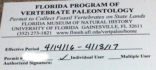
Photo : on the unlikely chance you are stopped by a game warden or ranger, you will want one of these permits to stay out of trouble.
While all of the Peace River has fossils, the most productive stretch starts around Fort Meade Florida and runs about 50 miles to just south of Arcadia – any further south and the river becomes tidally influenced and is not ideal for amateur hunting. The Bone Valley formation starts in southern Polk County near Fort Meade and is exposed near the surface all the way south through the towns of Bowling Green, Wauchula, Zolfo Springs, Gardner, Arcadia, and Brownsville. Along this stretch, the Miocene (and some Eocene) marine fossils are contained in the limestone bedrock of the riverbed – they weather out of the rock and are found loose in the river and along the bank. The native soil layers here consist of loose sand, clay, and clayey-pebble mix over the underlying limestone rock. Uneven underground erosion due to water movement causes sinkholes, voids, and pockets in the limestone, which are then filled with clay or clayey mix.
During seasonal heavy rains, flash floods will erode away large areas of the drainage basin and river banks – exposing new fossils and distributing them downstream. Hunting is relatively easy compared to the western US states where dinosaur bones often have to be laboriously chiseled out of solid rock. Along the Peace River, the fossils are literally laying around waiting to be spotted and picked up with little physical effort. Or, one can dig into the soft, wet, sand and clay to sift shovel-fulls of material for smaller fossils.
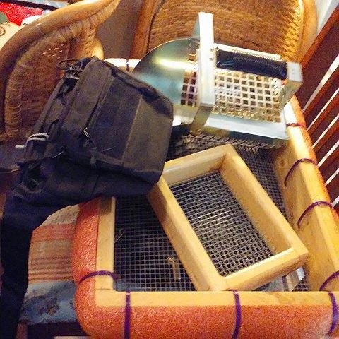
Photo : Fossil hunting gear. Sifters, shovel tool, and waist bag.
During our scouting/hunting expeditions, our equipment consisted of the following :
- Either a 16-foot (4.8m) canoe or two 10-foot (3m) kayaks (sit on top type).
- sifting screens with frames and floats (for use on dry land or in the water).
- small shovels
- probing tools
- cut-resistant gloves
- trusty Estwing rock pick
- long machete (for cutting vegetation or fending off snakes)
- pocket knife
- jeweler’s loupe on a short cord around my neck.
- small pack with lunch, camera, cellphone, and handgun.
- small cooler filled with bottled water and Red Bulls.
- empty duffle bag, specimen bags, and diapers to wrap and transport specimens.
- empty plastic garbage bag to carry out litter and trash we find or make.
THE SITES :
As luck would have it, Josh ended up making a connection through his job to the owner of a big piece of remote property that sits right on the Peace River. We would have exclusive access to an approx. 4-mile stretch of the river with permission to not only hunt in the river itself (via the state permit), but also to hunt on the banks adjacent to the river thanks to permission from the private property owner. In addition, there was no other public access or boat ramps within a 2-3 mile paddle up or downstream of the site. This stretch was also quite shallow and rocky, so fisherman and airboats largely avoid it. Only on rare occasion do you see another canoe or kayak passing through. Otherwise, the area is free of people, litter, noise, or other signs of human habitation. Land on both banks along this stretch of river were owned by large mining companies and industrial farming, and neither industry had touched or altered this part of the river. It is one of the rare portions of wild pristine river in Florida that has never been developed – it has an ancient and primeval feel to it.
Over the course of successive seasons, we scouted and hunted this stretch of river thoroughly and exclusively. We were likely the first people to recover fossils from this area of the river. It was apparent from the beginning, that the hunters and tour guides that haunt the Zolfo Springs and Arcadia areas did not frequent this stretch of the river – it was too far away from the boat ramps they could access. Casual hunters were not going to paddle for hours upstream against current just to reach a site, so we would be the first set of eyeballs to search the area. In addition, since we had permission from the property owner, we could keep our eyes peeled for artifacts. This area has also been inhabited by primitive humans for the last 13,000 years. Artifacts are often found, including arrowheads, pottery, and various tools.
Our expeditions to hunt this area took place over three years during approx. three dozen trips. All of these trips were during the seasonal dry months when the river height would be low and the rate of flow would be slow. Paddling against the current was a chore, but not beyond the ability of a typical able-bodied person. We hunted north and south of our access point by about 3-4 miles in each direction (until we started encountering development, or passed beyond the boundaries of where we had legal access to the land on the banks). Most of the scouting and hunting trips involved an entire day that started on the river at approx. 7:30am and continued until about 2pm or 4pm, depending on the weather. We would stop and rest about halfway through the day for a brief lunch consisting of a sandwich, some potato chips, some candy, and many Red Bull energy drinks. Usually we would turn around and head back to the ramp in time to get loaded up and on the highway home before dark.
During these trips, we recovered many hundreds of fossil specimens, dozens of interesting mineral specimens, and a handful of artifacts. We found so many fossils, that we had to start being picky and leave some behind. On one occasion, I brought home a 30-kilo chunk of fossiliferous limestone matrix that filled the center portion of our 16-foot canoe. At first we used the canoe exclusively because it could carry more gear and spoils. But, we eventually shifted to using small 10” kayaks due to the shallow and rocky nature of the river – all too often we had to climb out of the canoe and drag it over exposed limestone riverbed. That labor became very tiresome and took away energy from digging and searching for fossils. The switch to the kayaks meant we could carry less cargo, but we could also reach more remote spots and have more energy to search once we found a spot.
After searching dozens of places, we struck it rich on two spots in particular. One spot was on the northern stretch of our search area. The other spot was on the southern edge of our search area. The northern spot earned the nickname “The Rib Shack”. The southern spot was christened “Bone Island”. Both were very productive sites for fossil recovery and we focused the bulk of our attentions on these two “honey holes”. (For the uninitiated, a “honey hole” is a name for a lucrative fossil recovery spot that other hunters do not know about.)
This report will focus on the southern Bone Island honey hole and the specimens recovered from there over approx. a dozen days of searching and recovery work.
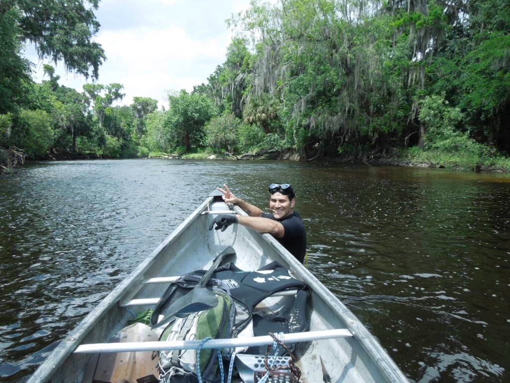
Photo : Josh wading outside the canoe, as we approach the Bone Island site. Water here is about waist deep.
DOWNSTREAM TO BONE ISLAND :
One of my previous fossil hunting reports mentioned the Bone Island spot. That report focused on an site much further downstream from Bone Island – close to where the river forks and starts getting close to a highway and bridge. You can find that report at the link following this article.
Reaching the so-called Bone Island spot involves putting in the kayaks at our ramp approx. 1.5 miles upstream from the site. We can drift leisurely at a slow speed with gentle current, scanning the banks and shallows for visible bones, teeth, or promising holes. Occasionally one will get lucky and find a bone or specimen laying in plain sight along the bank where it recently weathered out of the sandy-clay soil. On most trips we didn’t get that lucky, but we did make some decent finds on our first trip through the area – further proof that other hunters had not seen this stretch in a long time, if ever. These obvious, low-hanging fruit fossils would be picked up quickly by the first hunter who saw it at the busier sites like Arcadia. The first couple of trips were spent blindly poking around the river and finding small isolated specimens in different spots that looked promising.
Once we found Bone Island, we spent our subsequent trips going straight to this site at full speed paddle – to get there as quickly as possible, in order to spend more time searching and recovering. Using the downstream current to assist us, we could reach the site in about 30-40 minutes of paddling. The approach to the site was very shallow as the limestone river bed rose up to meet the highly-eroded banks. As you got closer, the water went from being black as coffee and upwards to 6 feet deep (8-10 in some holes), to tea-colored clear at about waist deep to almost crystal clear at depths of only 6 inches. In some spots, the water level was only ankle-deep and moving quickly through channels in the exposed rock. This shallow shelf tapers off slowly into deeper water before the river bends sharply. At the end of the shelf is an “island” of small and medium sized rocks that juts up about 6 feet above the water level during the dry season – the entire thing is under 6-10 feet of water during the wet season. During most of our trips to this spot, the mound of rocks sat in shallow and slow-moving calf-deep water.
What first attracted my attention to the rock mound is that is made a good spot to place some of my gear nearby while I sifted and searched the area. It was just big enough to use as a natural table to keep my pack dry and provide a handy place to put something. While doing this, one day I decided to excavate the entire mound down to the bedrock underneath and see what interesting things may have become caught up in the nooks and crannies between the rocks. Over decades or centuries, who knows what may have become caught up down there. Bones. Teeth. Artifacts. Trash. The idea of being the first person in this lifetime to look under those rocks was seductive. Josh thought I was nuts. Within 30-50 feet of the island mound was a productive set of rapids where we had found megalodon teeth and one large mammoth tooth. Josh was more of a diver and snorkeler than me. He wore wet suit and mask and would dive down into holes while I played the role of gator watch. I was the digging and sifting guy who poked around and focused on smaller specimens in more detailed work. We made a good team because our differing hunting styles meshed well when combined to thoroughly search an area.
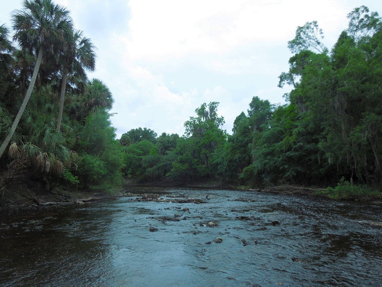
Photo : the view of Bone Island, as seen from the shallow area where we have to get out of the canoe and wade through ankle-deep water to the site. The rock mound can be seen in the distance, left of center.
While Josh would spend hours systematically searching the nearby rapids, I would spend hours meticulously moving rocks from one pile to another, while looking in between and under them for specimens. Both of us reaped rewards. It took me three sessions over three trips to completely deconstruct Bone Island and then move it back into it’s original place.
In the end, I had not wasted my time. I found quite a concentration of mixed fossils which included many examples each of the following : turtle scutes, alligator scutes, alligator teeth, snake vertebrae, alligator vertebrae, deer antler sections, shark teeth (several species), turtle bones, fish bones, deer teeth, horse teeth, broken mammoth tooth sections, dugong rib sections, cetacean teeth, and many unidentifiable bone bits (we call them “chunkasaurus”).
In addition to the rich trove of relatively-common Pliocene and Pleistocene fossils, there were also many recent Holocene (or newer) bones that had to be considered separately – they are nice finds, but not true fossils in the same sense of the much older specimens from the same site.
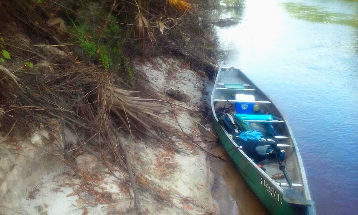
Photo : our 16' canoe loaded down with gear and our cooler. Above this spot and to the right is where we would sit to eat lunch, looking down over the canoe and bank.
There were a couple of really nice or rare finds in the rocks under that mount that made the entire ordeal worth it. The stand out finds were : a large section of Pleistocene horse pelvis, a mostly-intact dire wolf tooth, several large complete snaggletooth shark teeth, a small intact megalodon tooth, three nice complete examples of Pleistocene horse teeth, a large curved section of dugong rib (longer than most), a whale vertebra, I also hauled out quite a few small oddballs – some of which are still defying an authoritative identification. Besides fossils, there were no ancient artifacts to be found, but some more recent human finds were evident. I found the crushed but still legible remains of some old steel beer and soda cans from the 1970’s, before aluminum cans took over. I also found the shredded and fragile remnants of an old church summer camp t-shirt snagged deep under the rock mound near the base – apparently deposited there by the seasonal floods from one of the church camps along the river much further upstream. If I had to guess, it looked like it was from the 1980’s or thereabouts – not as old as the beer cans, but an unexpected find to see.
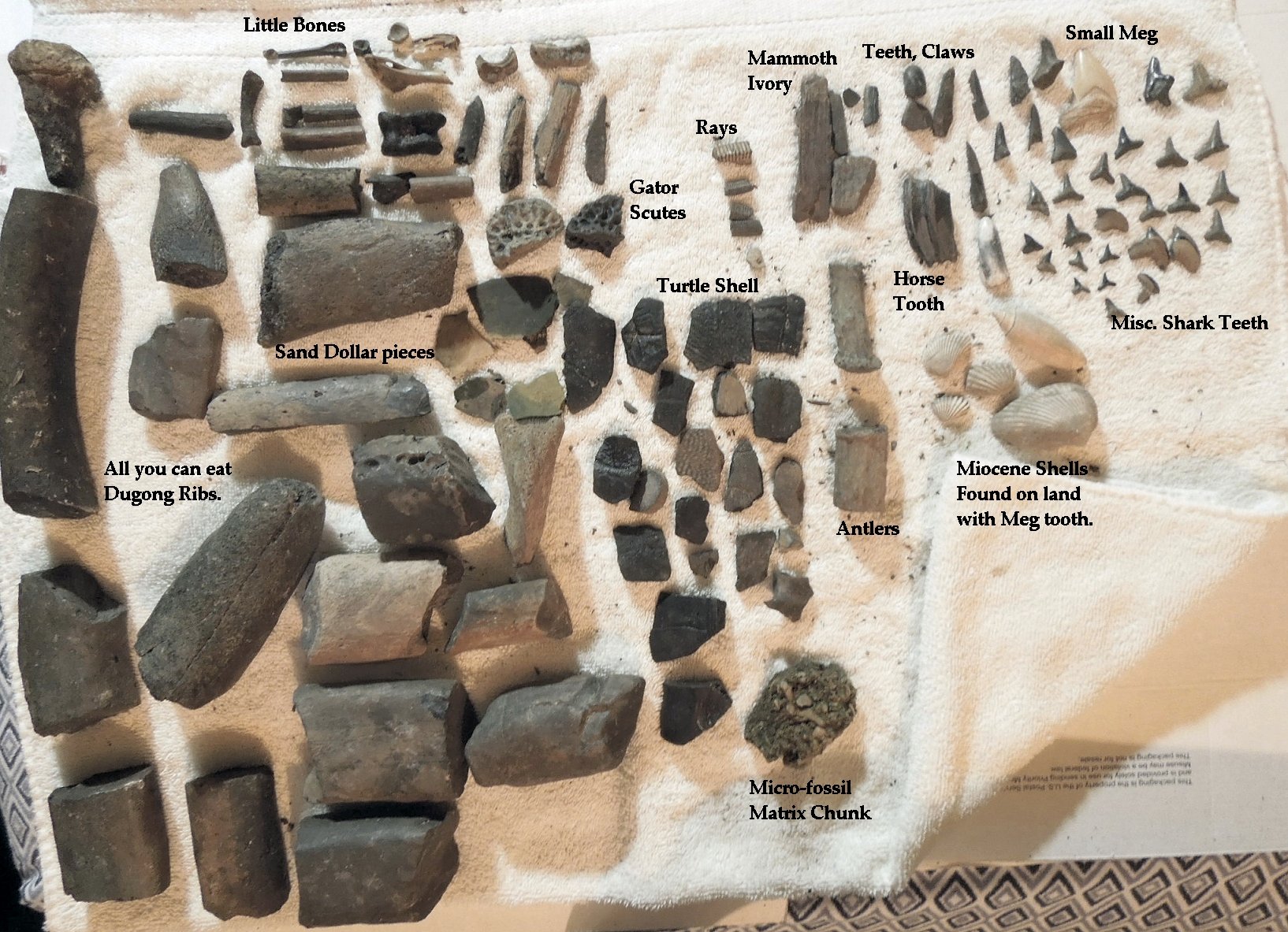
Photo : typical common specimens found at the site. Most in this photo are labeled. We found dozens to hundreds of similar pieces of each type. This is typical of what we would find in a first hour or two during the first trips.
A related stroke of luck resulted in the finds of an arrowhead, bone needle, and small stone tool – three unrelated artifacts found on the high ground overlooking the banks around Bone Island. This was the private property spot where we would have our lunch breaks at the site. While poking through and discarding some finds from the sifter, I stumbled across some pieces that had been carried to the same spot by the recent flash floods. In dirt were the three small artifacts – gifts from Mother Nature and legal to recover due to their location. As another sign of how pristine and rich this area was, the same lunch spot also had many turtle scute pieces and stray shark teeth littered about in the sand.
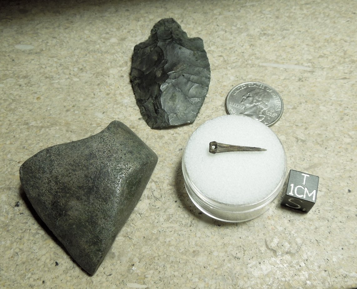
Photo : Thonotosassa point arrowhead (Middle Archaic 5,500-7,000 years old), unidentified bone needle, unidentified stone tool. Artifacts found near the site.
After several subsequent trips, the Bone Island honey hole had dried up. We stopped finding the good stuff, the big stuff, and the rare stuff. Continued digging and poking around only yielded more small shark teeth and assorted common (and more recent) turtle, deer, and alligator pieces. The supply of mammoth, megalodon, and other sexy stuff had been depleted in this spot by our searches. When we decided to stop searching this spot and concentrate on other spots, we worked to return Bone Island to it’s original state. I restacked the mound of rocks. We filled in any holes we dug. We re-distributed our sifting gravel and tailings. And of course, we carried out all of the trash we brought in and any trash we found.
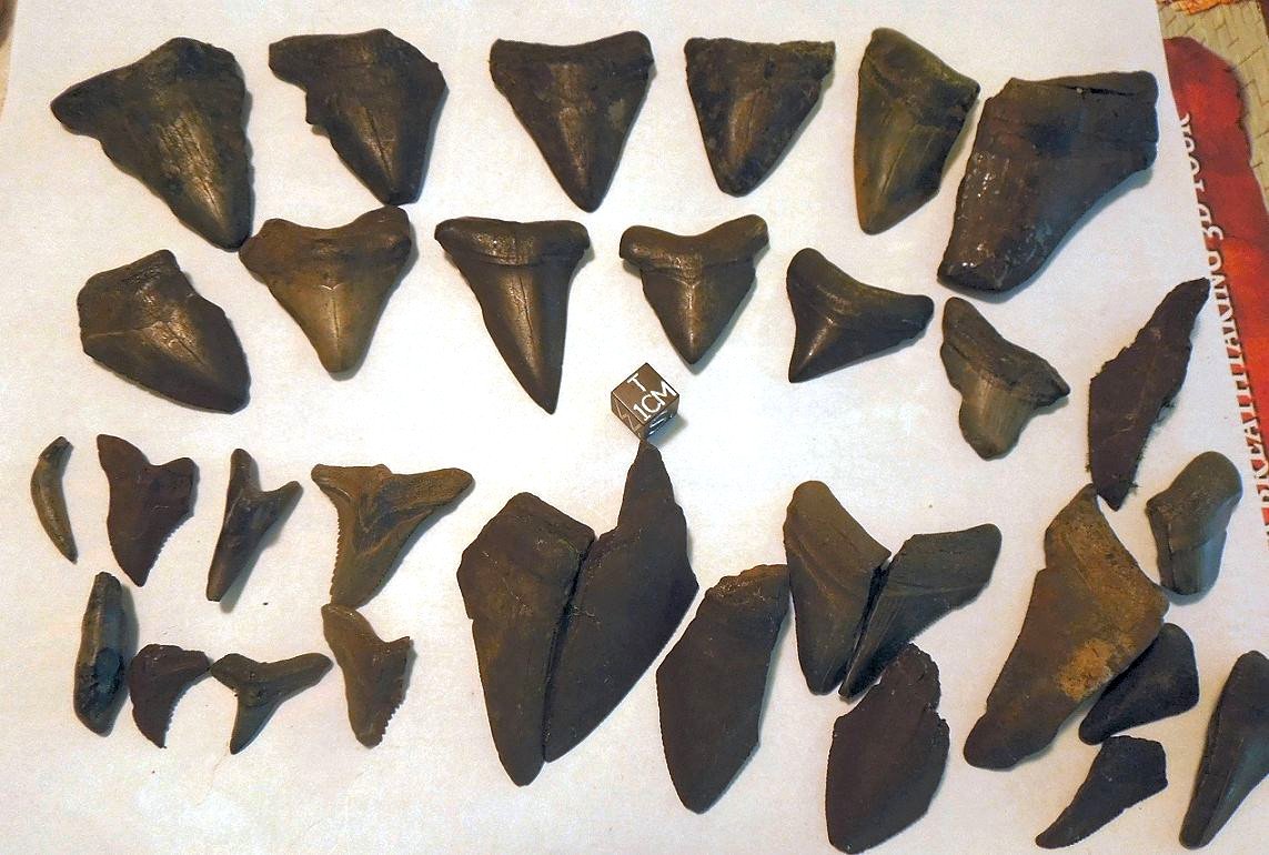
Photo : Megalodon and other shark teeth, recovered from the rapids at the Bone Island site.
On later trips, we would pass by the Bone Island stretch and pay a nodding tribute to it as we passed further downstream in search of new honey holes. Occasionally we’d stop to poke around for a few minutes and see if we overlooked anything previously. But we never found anything else of significance after those first couple of systematic searches. It will now take many years for the fossils to build back up in that bend of the river – future floods will wash out more bones and teeth to litter the riverbed and collect in holes and bends.
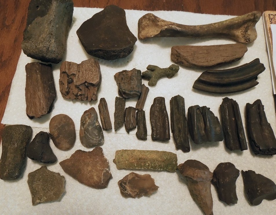
Photo : Various Pliocene and Pleistocene megafauna bones and teeth. Also some Holocene specimens.
Stay tuned for Part Two of this article, which will detail the finds from our northern honey hole, the “Rib Shack”.
My previous report on fossil hunting the Peace River - @galacticstone/fossil-hunting-in-florida-s-bone-valley-formation
All of my science blogs on Steemit - @galacticstone
Photo credits : all photos and videos shot by me, Michael Gilmer (Galactic Stone)
