Hi everyone!
How is everything going? Hope all of you are doing well! It's been more than a week since my last engineering blog was uploaded due to the fact that I've been extremely busy doing research. However that's good news; I'm now ready to launch my new Geology series, as promised in the past weeks. Please note that my Introduction to Cartography series is not over. I just have a lot to share with you and thought I would love to write some more.
This time I'd like to take the chance to make an introductory post regarding Geology, which is commonly known as the scientific field of observing and studying the Earth's interior structure and the way its structural layers were developed and shaped. Geology is also known as the study of the materials of which the Earth is made, focusing on their chemical composition, processes and changes over the interval of time described as the geologic history of the Earth. Please note that General Geology includes studies regarding the formation of the Universe and our Solar System, however we have got Geodesy for that, so we will be focusing on Tectonic Geology in this series.
As the title reads, please keep in mind that this is an introductory post. This basically means that I will try to present general information regarding Geology in a simplified manner so that nobody gets bored to death. Kidding. We will also take a look at the Earth's Geological Cycle and share general introductory information regarding the three main Subcycles it is comprised of. There's a high chance of learning a thing or two by reading through this blog, so stay focused!

Image Source: pixabay.com (CC0 Creative Commons Author: TheDigitalArtist)
Introduction
General Geology is the only exact science that depends on historical methods of research to this extent, which are indeed very useful tools mainly due to the fact that the vast majority of problems faced in this specific field cannot be described and solved mathematically. As a result any conclusions reached cannot be directly proven and are generally based on the laws of probability. However, there's always grounds for different viewpoints of the same situation regarding geological incidents and the way Engineers interpret those, therefore assumptions are initially made which are later slightly changed or even rejected. This feeling of uncertainty played an important role in inducing further development as it encouraged meticulous observations and inevitably stimulated Engineers' imagination, providing the fuel needed for technological and scientific development.
This scientific field's development has been highly dependent on theoretical knowledge gathered through observation from the early beginning. I'm sure most of you might think that is the case with all scientific fields, however it is actually not as in this case experimentation is limited, even with nowadays' technological advancement. Despite all obstacles placed by the scientific field's theoretical nature, vast amounts of scientifically proven technical knowledge regarding our home planet's creation and history are available nowadays thanks to tremendous advances made by Geologists and Engineers in general within the last century. Τhe accurate interpretation of the obvious results of major geological incidents that took place on the planet's interior or surface has played a very significant role in the extraction of information regarding the planet's geological history.
It is worth noting that the process of gathering raw data in Geology varies significantly compared to other exact sciences as the efficiency of the process depends on the Geologist's mental and physical attributes a lot more. Related scientific fields' development is based on the utilization of advanced equipment and instruments which make life a lot easier regarding the demanded precision of measurements made and data acquired. This is one of the main reasons why General Geology is considered by many as another historical scientific field, mainly due to the fact that the Geologist's personality and capabilities affect the quality and precision of raw data collected and therefore shape the outcome of any research according to the perception of nature of the Engineers involved.
Geology as a scientific field has changed and shaped the way Engineers perceive our planet concerning its structure. Scientists thought the Earth was a rigid body, and therefore deformation within its crust could be neglected, however oceanographic and geophysical research conducted during the 1960s provided scientific evidence about the creation of fresh layers on the seabed in ocean ridges, while large amounts of crust material were removed from those ridges at the same time. This served as proof that the crust is not as stable as we thought it was. Geologists believe that this also serves as proof that all continents were part of a supercontinent in the past, which was also formed when other smaller pieces of land merged together, all assumptions based on evidence that the bottom of the sea is constantly expanding. Boom. I know.
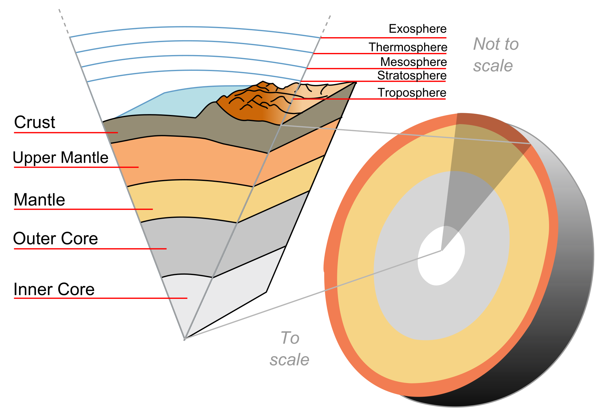
Interior Structure of the Earth./ Image Source: commons.wikimedia.org (Creative Commons Attribution-Share Alike 3.0 Unported Author: Jeremy Kemp)
Geological Cycle
Until recently the Earth's crust was considered to be a homogeneous rigid body made of rock, while no details regarding its composition were known. In reality, the crust is comprised of various irrelevant types of rock formations with different attributes and chemical compositions. Those different materials are produced by various natural and chemical procedures that take place as part of the process of the Geological Cycle during the time interval occupied by the geologic history of the Earth. The Geological Cycle consists of all geologic processes regarding the correlations and interaction between all fluid and solid layers of the Earth, that are observed and studied thoroughly. However, even if we do record and study all those processes meticulously, we still have a limited perspective of the bigger picture as described by the Theory of Plate Tectonics. More info on this coming within the next week.
The Geological Cycle of the Earth is mainly comprised of three subcycles, which are known as the Hydrological Cycle, the Petrological Cycle and the Tectonic Cycle. The Hydrological Cycle includes all studies and measurements regarding the motion of the water in the Earth's atmosphere, hydrosphere and lithosphere. Rock formations corrode from exposure to the atmosphere and the hydrosphere's procedures, and therefore reposited material from the Natural Terrestrial Surface ends up in the ocean. As a result, rock formations are created, fragmented, relocated and destroyed, all part of the significant process of the Petrological Cycle. Large parts of the fragmented and relocated rock formations are buried deep, a process that is later followed by the plaiting and lifting of huge pieces of the Earth's crust, which give birth to new mountain ranges. This procedure is part of the Tectonic Cycle, shaping our planet's Natural Surface by causing immersion of large pieces of land over long periods of time.
Geologists have been monitoring the motions of those materials within subcycles mentioned above for more than 150 years, and therefore vast amounts of accurate data that can be utilized by Engineers in order to reach safe conclusions regarding the nature of the Tectonic Cycle have been acquired. It is fair to say that if it weren't for the constant lifting of giant pieces of the Earth's crust due to tectonic activity, corrosion would have destroyed all surface layers of the crust and all materials, transported by wind and water, would have already accumulated in the ocean. It is obvious that the Earth's tectonic activity balances the destructive effects of corrosion on the Natural Terrestrial Surface, making life on Earth possible for humanity and allowing our civilization to survive and thrive. Now let's take a deeper look at each one of the three subcycles of the Geological Cycle.
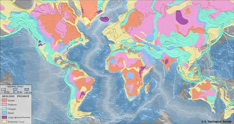
World Geologic Provinces./ Image Source: earthquake.usgs.gov (Public Domain Author: US Geological Survey)
Hydrological Cycle
The hydrosphere is actually a thin layer of water situated on the Natural Terrestrial Surface which expands into the atmosphere and lithosphere. More than 97% of the total volume of water on Earth is contained in the ocean basins, covering a total area of 1.36 x 10^6 km^2 with an average depth of approximately 3.7 km. Roughly 2.4% of the total volume of water on Earth is contained in ice deposits located mainly in Antarctica and Greenland, whereas only 0.02% of the total volume can be found in lakes and rivers. Furthermore, 0.00001% of the total volume of water is situated in the atmosphere in the form of clouds and dissolved steam, while approximately 0.579% of the total volume is enclosed in tiny cracks and porous gaps on the lithosphere's rock formations.
It is estimated that 3.6 x 10^4 km^3 of water evaporates from the surface of the ocean, whereas 6.2 x 10^4 km^3 of water evaporates from lakes, rivers, ice caps and soil every year. Amounts of water released into the atmosphere by plants are included in this estimation, while it is worth noting that this total volume of 9.8 x 10^4 km^3 represents roughly 0.03% of the total volume of water situated in the hydrosphere. It is also worth mentioning that this amount is approximately 300 times larger than the amount of water flowing in rivers at any specific point in time. This only goes to show that water doesn't stay too long in the atmosphere before returning to the ocean basins.
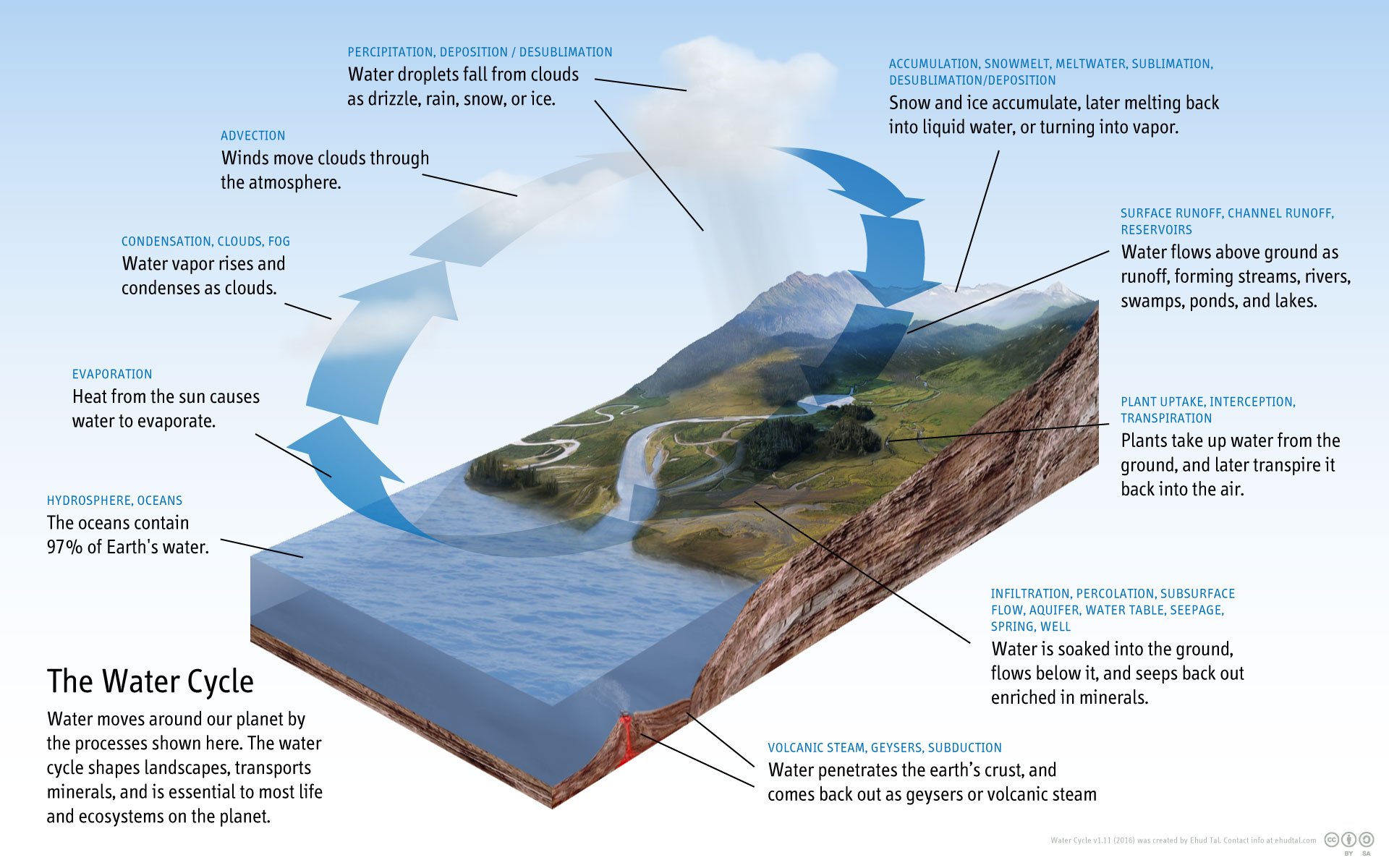
Diagram of the Water Cycle./ Image Source: commons.wikimedia.org (Creative Commons Attribution-Share Alike 4.0 International Author: Ehudtal)
Petrological Cycle
There are thousands of different rock formations found on the planet that are defined by their names, however Geologists avoid emphasizing in detail regarding all various types and focus on 3 main categories that all rock formations can be divided into: igneous, sedimentary and metamorphic rocks. Igneous rocks have been crystallized from melting state, after reaching temperatures of 1000 degrees Celcius. Rocks located in the Earth's interior are mainly comprised of a variety of minerals with different chemical compositions, which results in rock formations with multiple melting points. The crystallization of rocks is a very similar process to the coagulation of salt solution in water. As temperature declines, crystals are formed causing variations in salt concentration of the solution.
Sedimentary rocks are mostly rocks that have been transported close to the Natural Terrestrial Surface by wind and water. Most of these rock formations were reposited underwater, however they do include sediments that were created on land mostly due to the Natural Terrestrial Surface's interaction with the atmosphere. Sedimentary rocks are created and shaped in low temperatures as products of the Natural Terrestrial Surface's disintegration, when fragmented rocks undergo physical and chemical procedures induced by the weather and the Sun's electromagnetic radiation. These products of disintegration are then transported to the ocean basins by the flowing rivers.
Metamorphic rocks are mainly rock formations with an altered initial state due to exposure to conditions of high temperature and pressure. This happens when such materials are buried deep enough due to the Tectonic Cycle's procedures. Chemical reactions that occur help crystallize the fragments of minerals that sediments are comprised of and therefore give birth to new minerals which are commonly known as metamorphic rocks. Immersion is the very first process of the Tectonic Cycle and is followed by the lifting of metamorphic rocks which eventually leads to the disintegration of the Natural Terrestrial Surface.
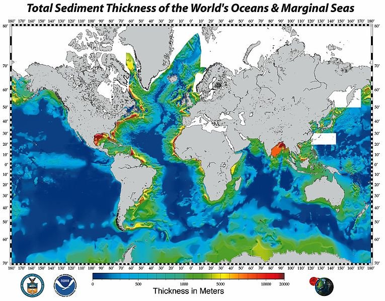
Total Sediment Thickness of the World's Oceans./ Image Source: commons.wikimedia.org (Public Domain Author: NGDC)
Tectonic Cycle
The Theory of Plate Tectonics indicates that the Geological Cycle with all its subcycles is nothing but a consequence of the tectonic plates' motions with visible effects on the Natural Terrestrial Surface. Solar energy absorbed by the Earth's surface and geothermal energy, which is causing the tectonic plates to move, are the main energy sources for all subcycles, which in combination with Gravity that pulls everything towards the center of the Earth are directly related to the tectonic plates' behaviour and motions. Immersion of rock formations of the crust close to the boundaries between tectonic plates caused by all factors mentioned above signals the beginning of the Tectonic Cycle which is often followed by lava flowing from the asthenosphere.
As the seafloor expands due to the tectonic plates' motions, ocean ridges are placed further away from the lithosphere towards a boundary of convergence between neighboring tectonic plates, a process that results in the plates being covered by a thin layer of sedimentary material. Close to the boundary area, the oceanic lithospheric plate moves towards the interior of the Earth and therefore its surface is heated due to friction force, causing the rock formation to melt which in combination with the lava flow creates island arcs parallel to the ocean trench.
The compression and bending of the sedimentary, igneous and metamorphic rocks induced by the process described above is causing destabilization and as a result the boundaries of convergence between tectonic plates are turned into mountain ranges which are connected to the island arcs created by the melting materials of the oceanic lithospheric plate moving towards the Earth's interior. It is worth keeping in mind that the boundaries of convergence between neighboring tectonic plates can differ from one type to another, which is a factor that induces complexity regarding the process of shaping tectonic plates' boundaries.
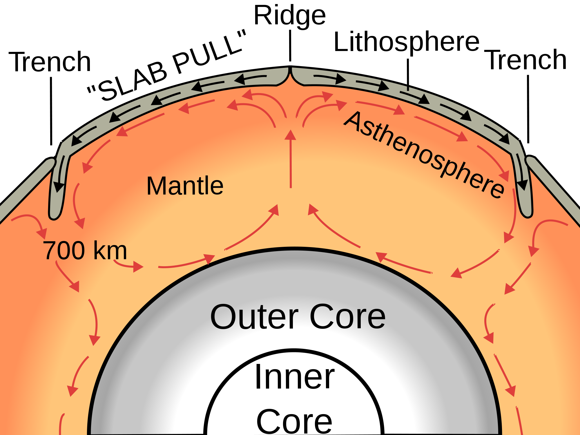
Oceanic Spreading./ Image Source: commons.wikimedia.org (Creative Commons Attribution-Share Alike 3.0 Unported Author: Surachit)
Alright people, that's it for today! I'm thankful that you took the time to read through this blog and hope you enjoyed it as much I did. That brings us to the end of the first part of this brand new Introduction to Geology series. As mentioned above, I have another Introduction to Cartography series going on and I will be publishing one episode of each series every week. Feel free to let me know if there are any questions in the comments below and I will do my best to respond in detail as soon as possible. Follow me at your own risk and stay tuned for more engineering blogs. :)

IMAGE SOURCES:
REFERENCES:
University Textbooks & Course Lectures:
Γενική Γεωλογία Ι/ General Geology I -RONDOGIANNI T.(National Technical University of Athens, School of Rural & Surveying Engineering, Course Lecture Notes)
Εισαγωγή στη Γενική Γεωλογία, Ανατύπωση ΑΘΗΝΑ 2003/ Introduction to General Geology, Republished ATHENS 2003 - DERMITZAKIS M., LEKKAS S. (National Technical University of Athens,School of Rural and Surveying Engineering, University Textbook)
Internet Links:
http://web.gps.caltech.edu/options/geology/Petrologic/Petrologic.html
https://study.com/academy/answer/what-is-a-tectonic-cycle.html


Thank you for your attention!
Hope you enjoyed this post and did learn a thing or two.
Follow me and stay tuned for more engineering blogs.
Highest Regards
@lordneroo
