In my job at the European Space Agency we look at what satellite applications can do for non-space sectors of society. Sometimes, however, you simply have to stop what you do and enjoy the majestic beauty of some of the images we get!
I have long believed that our space instruments - Earth Observation Satellites or the Hubble Space Telescope - deserve an award for the artistic beauty of their images. Here are 3 of my favourites from recent months together with a short description of what you are seeing.
I hope you will enjoy!
Ouarkziz crater, Algeria and Western Sahara
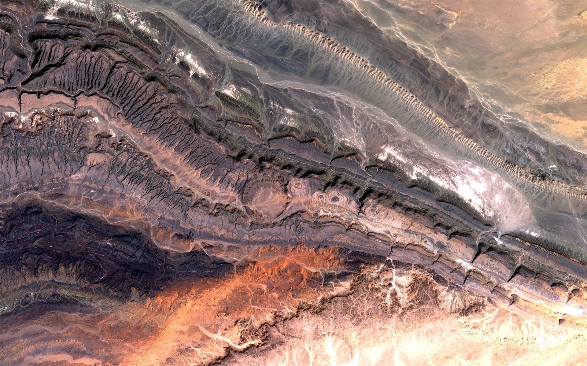
Image of the Ouarkziz crater and parts of the Anti-Atlas mountains bordering the Sahara Desert
This spectacular image covers part of the Anti-Atlas range in western Algeria. It was born from nothing less than a continental collision some 300 million years ago. Geologists believe it was once taller than the Himalayas but that its height was reduced over time through erosion.
Although the landscape here is mostly dry, as the mountains fall within the Saharan climate zone, some stream channels can still be seen. Some of these were created back when the climate was a lot wetter than today, while others stem from occasional water runoffs.
In the middle of the image, you can see the Ouarkziz crater as a big circle. The crater has a diameter of 3.5 kilometres and was created when a meteor hit Earth less than 70 million years ago when dinosaurs still roamed the planet.
Upsala Glacier, Argentina
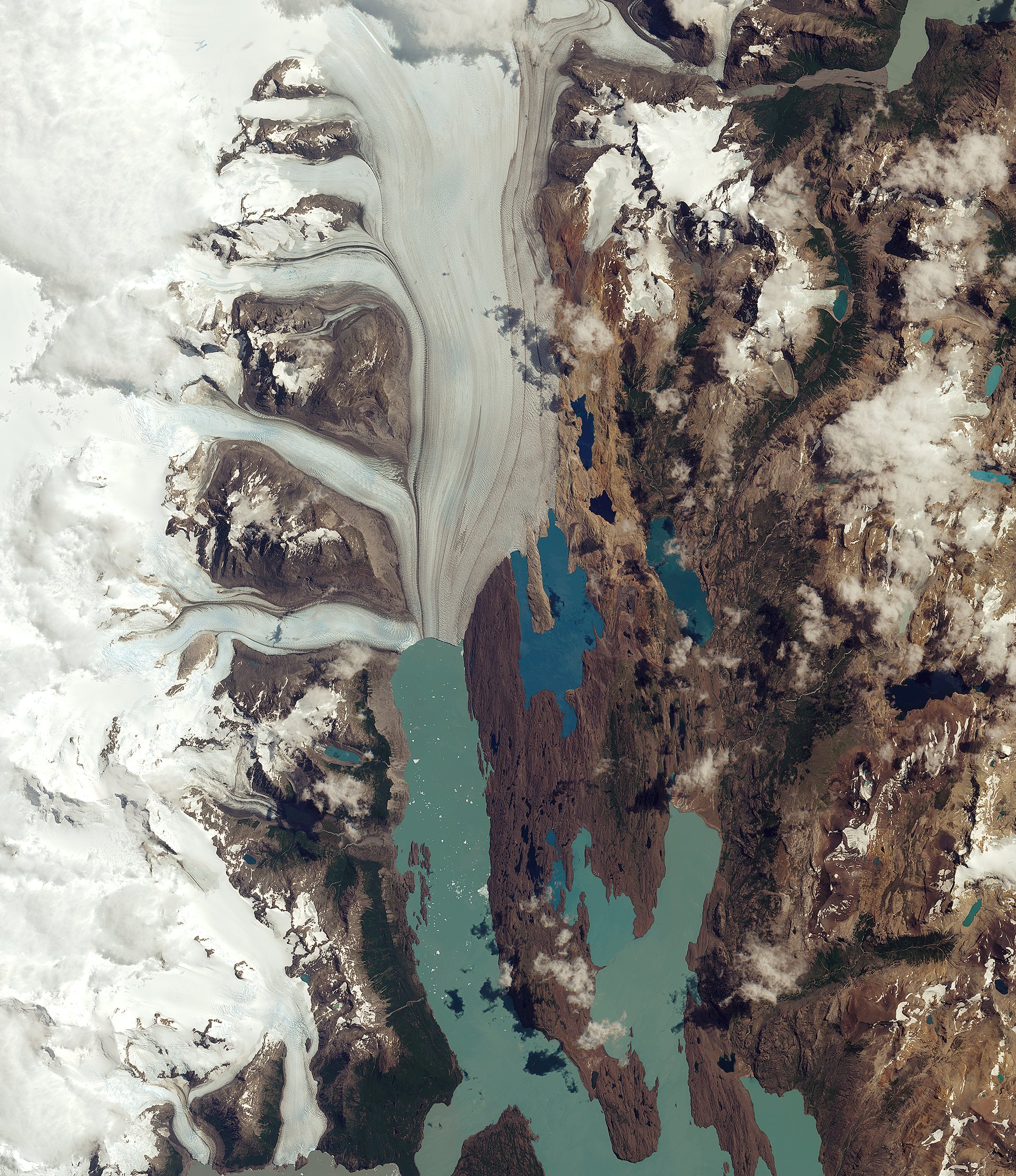
Image of the Upsala Glacier in the Santa Cruz province of Argentina
This image is of the Upsala Glacier in Argentina’s Los Glaciares National Park, which has been a UNESCO World Heritage site in 1981 and is the largest in the country, covering an area of over 7000 square kilometres.
These glaciers have been monitored closely by satellite images due to climate change. Indeed, many glaciers in the national park, and in the wider Patagonian Ice Field, have been retreating over the last 50 years due to rising temperatures. Over the past 15 years, the Upsala Glacier has retreated more than 3 kilometres.
Looking at the centre of the image, you can see small white dots across the lake. These are smaller parts of the glacier that has broken off and are now floating in the lake. The unique colour of the lake is due to “glacier milk”, which is suspended fine sediment produced by the abrasion of glaciers rubbing against rock over time. The darker lines following the flow of the glacier are moraines. These are accumulations of rock, soil and other debris, including glacial milk, that have been deposited by the glacier.
Uintah Basin, United States

Image of the Uintah Basin in Utah, US
This gorgeous image is taken of the Uintah Basin in northern Utah. The image is characterised mostly by barren land interrupted only by red, representing farmland, and rivers cutting through the landscape. The agriculture fields are seen as red due to the false colour processing applied to the image to detect vegetation in an otherwise dry and mountainous landscape. This showcases one of the many use-cases of Multispectral Instruments, as the stark contrast to the less-vegetated areas across the semi-arid region makes it easy to detect and monitor the state of vegetation.
In between the many agriculture fields on the upper left part of the image lies the city of Vernal. Because pavement and rooftops reflect no near-infrared energy (or at least very little compared to healthy vegetation) these urban areas will appear blue and white in an image like this. The long, light-brown rectangle shows the location of the regional airport.
On the top-right portion of the image, you can see parts of the Dinosaur National Monument. The park is home to hundreds of dinosaur fossils as well as scenic canyons that have been cut by winding rivers.
In the centre left of the image is the Uintah Basin, used for oil and natural gas production, seen as tinted blue. The extraction sites are scattered across the landscape as angular fields connected by numerous access roads. The large black and dark blue structures are evaporation ponds, likely used for wastewater from the oil and gas extraction activities.
Want to try processing new satellite images yourself?
All images above were taken by the European Sentinel 2 satellites. The image processing has been done by ESA, the European Space Agency. You can download the raw data from these yourself for free here, which can be processed professionally by the free tool snap. Or you may want to find and process images online here!
I hope to share more of these breathtaking images and continue making it a regular theme for my steemit blog. If there are parts of the world (perhaps where you live) you want to see an image of please let me know and I’ll dig it up!
Thank you for reading this far! My next posts will likely cover:
- “My conversations with 25 Astronauts, what it taught me about life, our planet, and much more”
- “A day working at the European Space Agency, suesas-sciencechallenge!"
- “Incredible things we can now do with satellites! #2”
So Follow me and stay tuned for more!