A new week has just begun and a new weird phenomenon is out to satisfy your curiosity! Since the last phenomena on the list were quite "peaceful" I figured I should shake you up a bit today. Wanna join me on a storm hunt? Come on!
Storms can be really violent, leading to flooding, hurricane-strength winds that damaging everything they meet in the their way, what we're looking through today is like a doomsday scenario. Now, jump on that jeep and let's go chase the storm!

(Image source: flickr.com)
Step by step
A wind shear (a difference in speed and/or direction within an air current) above the ground causes warm moist air to spin around parallel to the ground. Above it there is a colder mass of air that which, due to its higher density, does not allow for the warmer and lighter rotating air current to penetrate it and move upwards. When the rotation is strong enough, the wind shear can force the draft upwards by tilting and rising it all the way through the colder drafts above it. Those two cold and warm drafts entwine and start rotating separately creating a mesocyclone.
Now we have an updraft of warm air and a downdraft of cold air, which in a regular storm would lead to rain through condensation of the warm air moisture, but not in our case! This vortex will keep spinning feeding the cloud with moist and bringing catastrophic currents to the ground, sweeping everything away.
Hail the size of baseballs might start falling and tornadoes are also likely to happen. The storm may not stop for a couple of hours and it won't stay in one place, as it can travel for more than 10 miles far. Can you see it coming towards us? Better run before it gets us!

Dude, what was that we just survived?
It was a supercell storm! One of the rarest storm types that wreak havoc with torrential rains, instant floods, thunder, hail and tornadoes. You can meet them theoretically everywhere on the planet, but they are most common in the "Tornado Alley" of the US Great Plains and the "Tornado Corridor" of south America.
Supercell storms have three main categories depending on the amounts of precipitation:
- Low Precipitation (LP): with light rain or hail
- Classic Supercell
- Heavy Precipitation (HP): dangerous storms with heavy rain and hail
but it's sometimes hard to define them as within their life cycle they may turn from one form to another.
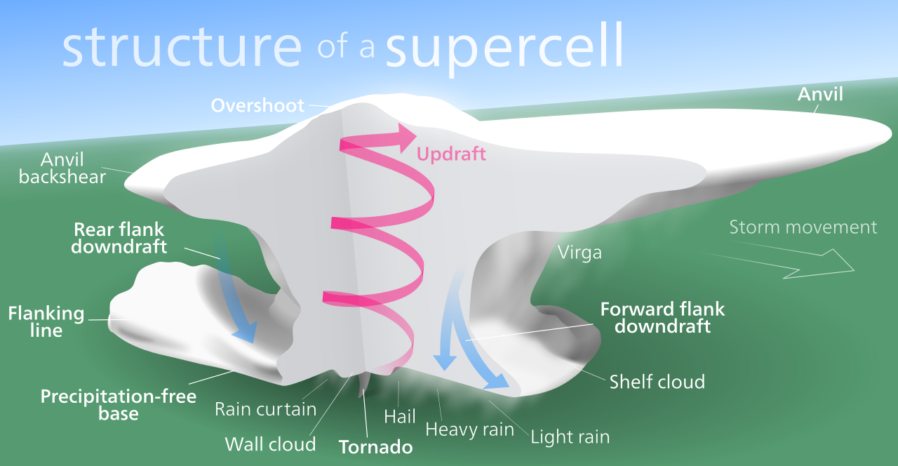
Their basic characteristics are:
- Anvil: The cloud where a supercell is formed resembles an anvil that usually faces the direction towards the storm is moving.
- The precipitation-free base: which works as the main draft influx area.
- Wall cloud: the point where the precipitation and precipitation-free areas meet. Those wall
- Forward flank downdraft: where the heaviest precipitation occurs.
- Rear flank downdraft: which is not fully understood yet, but is believed to be responsible for the formation of tornadoes.
(Image source: en.wikipedia.org)
Let's refresh what we've learned through a short video:
References
weather.gov
weather.com
higginsstormchasing.com
wikipedia.org_1
wikipedia.org_2
Thank you for stopping by and giving this post a read. I hope you enjoyed it! If it got your curiosity-radar on, you can check some of the previous articles on this series:
22 - Penitentes
23 - Explosive Lake Nyos
24 - Ball Lightning
25 - Moeraki Boulders
26 - Psychedelic Swamp
If you please, feel free to pay a visit to my blog and check out my short stories along with plenty of educational posts and of course lots of doses of troll-teaching!


Until my next post,
Steem on and keep smiling, people!
