Official Report & Point Review of Mistake – Reference Number: OMG*-1087- NASA.I
MEMO Record and Complete Informational Thread

CONTENTS
MEMO 1: For Your Reference/FYR with Attachment (Photo and Analysis)
MEMO 2: Reply to MEMO 1. For Your Action/FYA -Action Code:FTBWBGF
EVIDENCE
MEMO #1 – For Your Reference/FYR
FYR\ Dated: CLASSIFIED
TO: Myron Driddle -NASA.I- IXTACT Department of Satellite Imaging-Photographic Processing
FROM: Bill Maxton -NASA.I- IXTACT Department of Satellite Imaging-Analysis & Scientific Recommendations
SUBJECT: Image 8C - Newest Imagery from IXTACT satellite
Satellite Location: 000.154843-SQX \\// 156.871664-SQY.
Approximately 98 Km above Mars. Ice-Lake Region, Plains of Oddyssius.
BODY of MEMO:
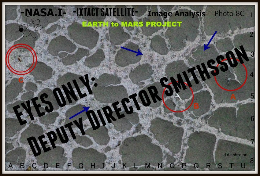
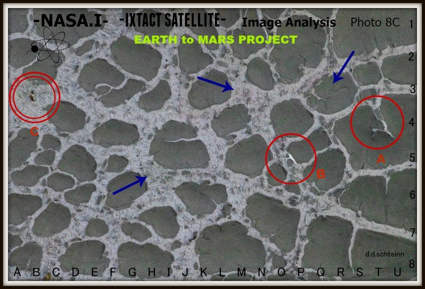
Myron. Thanks for the latest imagery from IXTACT. You were away on vacation in Bismark last week, so I took some liberties and grabbed the stack of latest images of Mars from your desk while you were gone. Hope you don't mind. Most photos didn't show much promise for analysis, except that Photo 8C. Incredible! I sent my Digital Analysis file and photograph (enclosed), on to Deputy Director Smithsson in D.C. He's meeting with the President Tuesday.
Let me know what you think. -Bill

Visual Reference Grid-Quads (GQ) added to photo 8C for easy location of points of interest. Each point analysis outlined below. Example: Lowest Blue Arrow found at GQ: G-6
ANALYSIS SUMMARY -- Author: Bill Maxton
EARTH to MARS PROJECT/Sustainable Life on Planet Mars
FINDING 1. --Tectonic Upheaval-- (Circle A) GQ: T-4
Appears to be some sort of tectonic upheaval. Strong evidence of past volcanic activity. Cone is now filled with ice component, most likely composed of Carbon dioxide or Oxygen, much like channels found throughout entire image. Northerly lava flow-zone leading out of volcanic cone/fissure suggests both lava and older pyroclastic flow and resulting Lahar, that breached and blocked E-W riverine channel with flow detritus, North of the Lahar fan (GQ: T-3.8).
Large, round dam in stream-center was no doubt created by Lahar debris flows, either during past, warm-climate stream flows, which are now frozen over due to more recent glacial activity, or Lahar flow happened during glacial activity, resulting in initial melt, then re-freeze blockage of ice channels, and subsequent blockage of entire ice-mass flow. Lack of glacial melt Moraine lakes at Lahar margins suggests activity occurred during warm climes.
FINDING 2. -- Presence of Gas Hydrates-- (Circle B) GQ: P-5
Massive buildup of ice in and alongside major frozen channel. Evidence of interaction between atmospheric gasses and cold/high pressure conditions, resulting in condensates that freeze very rapidly into lattice/matrix-type ice formations. Often very porous and gas-rich, these gas hydrates, or Clathrates, suggest the possible presence of living organisms in large number, exhaling respirational CO2 into the Martian atmosphere, or, an even more likely scenario: cold climate-adapted algal symbionts discussed in Point 3 below, exuding Oxygen that is then trapped into these large, gas hydrate formations over time.
FINDING 3. --Algal Life Forms! -- Blue Arrows @ GQ: R-2 / K-3 / G-5.5
All points of interest (arrows) show green and orange color-cast in many areas of photo. When microscopically viewed with Quadro-Lineal Gas-Infusion Imphoriotettic PhaseBiometric Analysis (QLGIIPBA), suggests the presence of a symbiotic relationship between green, photosynthetic-based algal growth, and anaerobic, ferrite-based microorganisms within the Martian soil along the channel soil horizons.
These space-based, photosynthetic/ferritic symbiont arrays are often labeled Nmumorhyophoeretic ferreo-diastimoitalites. All three points of interest in photo 8C show a contiguous mantle of these bio-growth patterns, both within and without the channel structures. These organisms MAY be the source of the Calthritic Oxygen gas that was discussed in Point 2 above, and a great discovery, adding further to the possibility of human habitation of Mars.
FINDING 4. --BIG GAME HUNTING ON MARS!!--- (Circle C) GQ: B-3
This may seem a bit fantastical, but based on the evidence thus far presented from Photo 8C, we may be onto a breakthrough of absolutely astronomical proportions. Utilizing the new, state-of-the-art, bi-image comparison software, aptly titled I.T.T.L.A.A.*, recently developed by BS2-Imaging Unlimited, shows great promise. This process utilizes coupled-image comparison metrics for analysis between space-based imaging and Earthbound Ecosystems. In this case, very accurate satellite image comparisons of visual events on the Martian landscape, and similar events of wintertime activity in the Yellowstone Basin of Wyoming, USA.
The two figures in the enclosed circle, highly suggest the unfolding of a predator/prey interaction. I believe this portion of the image portrays a larger, prey-based object, displaying the classic, oft-circuitous pattern of a predator evasion technique, known on the Yellowstone Plain as 'circling'. This activity is often seen on Earth via satellite, displayed by the species C. canadensis (Rocky Mountain Elk) of the Yellowstone Basin, when pursued by the first order predator C. lupus (Timber Wolf) in said-such basin interactions.
Utilizing the I.T.T.L.A.A comparison analytics, the two objects in this photo appear to portray the classic behavioral stance found in these types of interactions. I will go out on a bit of a limb here, analytically speaking, and suggest that this may be some sort of here-to-for unknown large predator and prey species interaction, not previously noted on the Martian Landscape; lending credence to the Oxygen discussion, and even the possibility of a potential food source for human habitation of Martian surface.
MEMO #2 -- Reply to MEMO #1:
F.Y.A.\ Dated: CLASSIFIED - Action Code: FTBWBGF*
TO: Bill Maxton -NASA.I-IXTACT Department of Satellite Imaging-Analysis and Scientific Recommendations
FROM: Myron Driddle -NASA.I-IXTACT Department of Satellite Imaging-Photographic Processing
SUBJECT: Reply to Memo of Date: CLASSIFIED -Regarding Image 8C.
BODY of MEMO:
Bill. Oh dear. This may not be good. Unfortunately, my son took that picture, not the satellite. It was taken out by the neighbor's garbage can last Wednesday evening. It's a close-up of their leather Ottoman from the back porch, that got rained on and ruined last summer. I processed that print in the lab for my son, for an assignment in his 10th grade Macro-Photography class.
Don't know HOW it got into the stack. Hope this doesn't cause any problems.
-Myron
High Tech Science Speak Acronym Guide (H.T.S.S.A.G.)
*OMG - Office for the Mitigation of Goofups
*FTBWBGF - Fix This Before We Both Get Fired
*I.T.T.L.A.A. - I Think They Look Alot Alike

Please Check Out My Other Posts, If You So Desire
~ALL ORIGINAL CONTENT~
SHORT STORY-HUMOR
A Letter From The Cat
To Be A Bee At The End Of "To Be"
Happy Curmudgeon Halloween
POETRY
One Minute Poem-Ode To The First of November
CARTOON
Oh To Be A Cat Today
PHOTOGRAPHY
If Tulips Grew On Mars // A Grassy Road After Winter Rains // Fall Leaf In Difficult Light-Color // Simple Sunset-Color // Shrubbry Up Close-B&W // Photo Challenge 15/Spider Webs-Humor-Autumn Beauty // Photo Challenge 15/Spider Webs 2 // Photography Challenge 15/Spider Webs 1
